The Year the Earth Moved
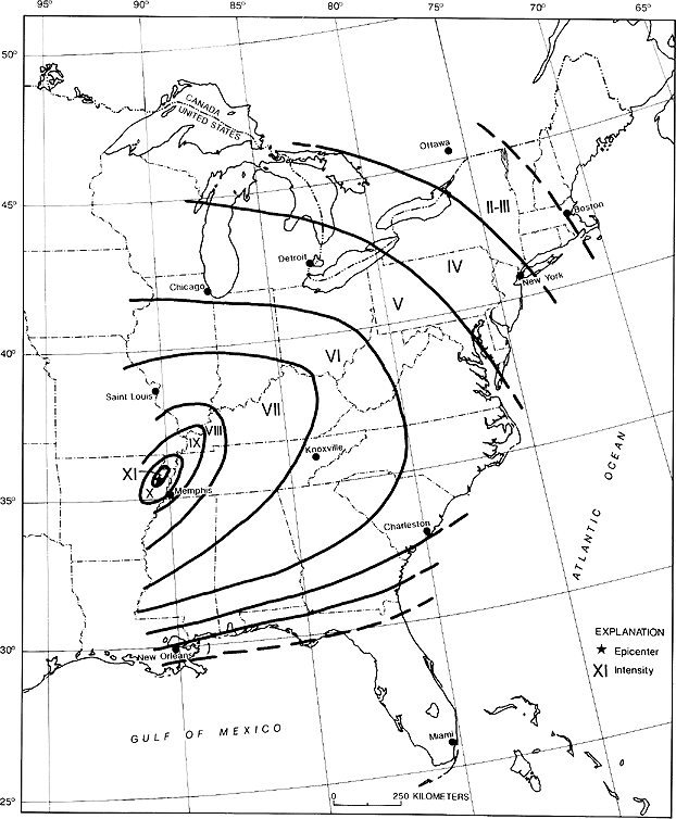
Isoseismal map for the Arkansas earthquake of December 16, 1811. Map courtesy of www.usgs.gov (United States Geological Survey)
By PJ Martin
Editor
The Herald-News
What would you do if you were suddenly awakened in the middle of the night by your whole house shaking violently? Well, that’s exactly what happened on Monday, December 16, 1811, at around 2:30 a.m. when an earthquake centered just southwest of Blytheville, Arkansas suddenly struck.
Scientists now believe the first quake would have measured 8.6 on the Richter scale. Then again around 8:15 a.m. another huge quake hit centering around Steele, Missouri, and scientists estimate it as an 8.0. As the day wore on, more aftershocks occurred ranging anywhere from 6.0 to 8.0. For people living in 1811, they must have thought the world was ending.
A young woman named Eliza Bryan wrote this account of the quakes:
“About 2 o’clock we were visited by a violent shock of the earthquake accompanied by a terrible noise… The noise sounded like thunder…The house shook and seemed to tilt…So we all ran outside. From then until dawn, we stayed in a lean-to…We did not live in our house for twelve to eighteen months after the first big shock.”
In 1816, Eliza wrote, “It is now four years since the big quake and we still feel slight jarrings now and then.”
Col. John Shaw was traveling from Wisconsin and had stayed the night at a home in Sikeston, 30 miles from New Madrid when the first quake hit. He traveled to New Madrid the following day and wrote a letter to Lexington, KY.
“I never before thought the passion of fear so strong as I find it here among the people…Several men, on the night of the first shock, deserted their families and have not been heard of since…Many suffer emotional trauma and various post-disaster psychological disorders from which they would never fully recover.”
Many people think that because the epicenters were in Arkansas and Missouri it would not have affected anyone in Kentucky, but they would be wrong. The quakes were so strong that maps indicate most of Kentucky felt at least a 7.0 on the Richter scale. Although homes were not completely destroyed in Kentucky many chimneys and brick buildings were damaged. Historical records state the quake was felt as far away as Hartford, Connecticut, New Orleans, Louisiana, and Canada.
It was felt by President James Madison and his wife Dolly at the White House and church bells rang in Boston, Massachusetts.
The first large quake was just the beginning. After the first another was felt about a half hour later, followed by over 20 aftershocks before daylight. The strongest aftershock, a magnitude 7.0 is referred to in documents as the “dawn aftershock,” occurred around 7:15 a.m.
Major damage to homes and businesses occurred. Landslides were reported in North Carolina, Kentucky, Tennessee, Arkansas, and Missouri, enormous lakes were formed by the rerouting of rivers, and boat operators reported that the Mississippi River ran backward carrying their boats and barges during the February 7th quake.
A retired boatman named Zadac Cramer numbered the islands of the Mississippi River from #1 – #127. These were published in the first edition of The Navigator in 1801. This helped many boat captains navigate the river during the day. At night it was too dangerous to navigate so the boats would tie up to shore.
A captain named Paul Sarpy had tied up his boat to island #94 which unannounced to him was a pirate location. Sarpy and his men went ashore to look around and happened upon a pirate encampment. They returned to the boat and quietly moved it around the island and further down the river and tied it up again.
During the night tremors shook their boat violently. The next morning when the fog lifted, the entire island #94 had disappeared, pirates and all.
The same is true for island #32. Several of the Mississippi islands were inhabited by Indian tribes, pirates, and hunters. To this day, the number of people who died as a result of the quakes is unknown. Those people were never accounted for thus no accurate number can be given. The number of deaths was estimated at 500 in six states; however, the actual number is probably double that. Remember, history books record that during the years 1811 – 14, only around 15,000 people were living in the states.
Many crevices were opened in the ground, spewing hot water, and large sandy deposits, known as sand blows dotted the landscape. Sand blows are a result of liquefaction. Earthquake-induced liquefaction is when the sandy sediment is infiltrated with water making it act as a liquid. When the water pressure increases to equal the surface soil the sediment liquid flows upward and out. This can cause landslides and damage infrastructure.

Liquefaction caused by the earthquake resulted in a sand blow. Illustration by United States Geological Survey
Seismic Tar Balls were small to golf ball-size tar balls found in the sand boils and fissures. Earthquake Lights were lights that flashed from the ground. It is caused by quartz crystals being squeezed. The phenomena are called “Antseismoluminescence.”
As described in letters by survivors, the skies turned dark during the earthquakes, the air smelled bad, and it was hard to breathe. Scientists believe that it was smog containing dust particles caused by the eruption of warm water into cold air.
The animals were reported to act strange before the earthquakes began. Domestic animals were nervous, excited, and wild. Snakes came out of the ground from hibernation. Flocks of ducks and geese landed.
Early in the events, an engineer in Louisville, Kentucky named Jared Brooks created a machine that today would be called a seismograph. He used springs, pendulums, and pins that recorded 24 hours a day measuring the quakes. From December 16, 1811, to March 15, 1812, he kept notes and reported 1,874 tremors. He classified 8 of them as violent, 10 as severe, and 35 as moderate, the rest he classified as generally or barely perceptible. Brooks was recording tremors approximately 250 miles from the source so there may have been more small quakes not felt by his machine.
Perhaps the most evident change that can still be seen today is Reelfoot Lake which was created as land shifted up and other areas sunk forming the lake.
What began on December 16, 1811, turned into years of nightmare life for many in the states affected by the New Madrid fault line. There were thousands of aftershocks, of which 1,874 were large enough to be felt in Louisville, Kentucky. Scientists today state that the New Madrid earthquakes were the strongest quakes recorded in North America east of the Rocky Mountains.
The New Madrid fault is still averaging over 200 seismic events per year according to the United States Geological Survey and they estimate that huge earthquakes like the ones in 1811-1812 occur every 500 to 600 years. The last earthquake large enough to cause damage occurred in 1895 estimated as a 6.7 near Charleston, Missouri.
To read more about the strange occurrences: http://new-madrid.mo.us/132/Strange-Happenings-during-the-Earthquake or https://www.uky.edu/KGS/pdf/InFocus/IFspring2000.pdf.
A current-day list of earthquakes in Kentucky can be viewed at https://earthquakelist.org/usa/kentucky/.